By Julio A. López, Editor-in-Chief — Venezuela’s map of gas transportation projects reveals far more than a network of pipelines. It illustrates the scale of the challenge the country faces in transforming its vast natural gas resources into an efficient supply for households, industries, power plants, petrochemical complexes, and eventually, export markets.
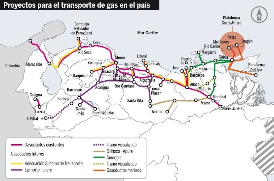
The first conclusion emerges from geography itself. The greatest growth opportunities lie in eastern Venezuela and offshore, including Plataforma Deltana, Dragón, Patao, Mejillones, Río Caribe, and the Güiria–Margarita–Cumaná corridor. Yet a substantial share of the country’s largest consumption centers and industrial infrastructure lies hundreds of kilometers to the west. This imbalance between where the gas is located and where it is consumed remains one of the main structural challenges for the Venezuelan industry.
The map distinguishes existing pipelines from multiple future systems, including transportation upgrades, the Northern Llanos Corridor, the Orinoco–Apure Corridor, Sinorgas, planned segments, and offshore pipelines. Taken together, these projects reflect the ambition to build a true national gas backbone.
At the same time, they reveal something even more significant: Venezuela still lacks a fully integrated network capable of connecting its new production sources with all of its major domestic markets through a system flexible enough to meet future demand.
The existing corridor crosses much of northern Venezuela, linking areas such as Maracaibo, Río Seco, Morón, Yaritagua, Guacara, Caracas, Altagracia, Anaco, and Maturín. Building upon that infrastructure, new projects aim to strengthen connections toward the Llanos, the southern industrial region, and offshore production areas.
The strategic focal point lies in the east. Connecting offshore fields to Güiria, and subsequently to the onshore pipeline network, would make offshore resources available to the domestic market as gas. From there, natural gas could supply the eastern industrial corridor, support power generation, and move toward the country’s central regions.
However, the map also makes clear that developing a gas field alone is not enough. A reservoir without evacuation infrastructure may possess enormous geological value while offering very limited immediate commercial value.
Monetizing natural gas requires production, processing, compression facilities, pipelines, compressor stations, storage, commercial contracts, and customers able to pay for the supply—all at the same time.
A second major takeaway emerges in central and western Venezuela. Planned connections to Barquisimeto, Barinas, Santa Inés, Puerto Nutrias, La Fría, and El Piñal suggest a strategy to extend natural gas service to regions that have historically been less integrated into the country’s primary gas system. Such expansion could reshape the energy mix across important industrial and agricultural corridors.
The relationship between the gas network and the power system also stands out. Venezuela operates thermoelectric plants that depend on a stable supply of natural gas. When gas is unavailable, power generation often relies on more expensive liquid fuels that could otherwise be used for higher-value purposes.
For that reason, expanding the gas transportation network represents far more than an oil and gas policy. It also constitutes an electricity, industrial, and fiscal policy.
The third element carries geopolitical implications. Plataforma Deltana and northeastern Venezuela’s offshore developments place the country within a new regional reality. Trinidad and Tobago needs additional gas molecules to sustain its processing and LNG infrastructure. Guyana continues to expand its offshore industry rapidly, while Suriname is emerging as a new energy frontier.
Eastern Venezuela can no longer be viewed solely from Caracas. It forms part of a much larger Atlantic energy province.
This is precisely what we have defined as the Atlantic Energy Arc: the corridor stretching from eastern Venezuela and Trinidad and Tobago to Guyana and Suriname.
Viewed through that lens, the map takes on another meaning. Offshore pipelines serving eastern gas fields are not merely national infrastructure projects. They could become the first links in a regional energy architecture capable of connecting Venezuelan reserves, Trinidadian infrastructure, new offshore developments, and Atlantic markets.
There is, however, one essential caveat. Much of what appears on the map represents future projects, conceptual segments, or infrastructure whose actual operational status still requires technical evaluation. A planning map does not necessarily reflect existing capacity.
The conclusion is clear: Venezuela’s greatest natural gas challenge is not simply proving how much gas it possesses, but building the system capable of delivering it.